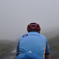
Derbyshire Freemason Richard Ward has raised £1,000 for the 2025 Festival by cycling Coast to Coast. Here he talks about his journey and shares his fundraising story.
The C2C route from Seascale to Whitby is well known amongst cyclists. It’s a bucket list item for many of us. A couple of friendly fellow competitors in the Time Trials run by Matlock Cycling Club were going on the mass ride organised for the last weekend in June 2019. By December 2018 I was too late to register. All places had gone by the previous September!
Never mind, a solo ride would let me ride at my own pace and not worry about holding other riders back. It was going to be easy to get to Seascale on the Friday. Brother Andy Slack would take me up in his people carrier. How to get back from Whitby? Asking the fellows doing the organised ride how they would get back gained no hints and tips about public transport, they were all getting lifts home from relatives. One youngster suggested I ride back to Bakewell from Whitby on the following day!
He had a point. A good night’s sleep should make the trip back feasible. Using the Ordnance Survey facility on Bing Maps, a route for the ride home was easily and quickly determined. A brief session on the Internet found a couple of convenient places to have bed and breakfast. Bookings were made for the night of 5th June in Seascale and the night of 6th June in Sleights near Whitby. All was ready, that is except for the bicycle and my body…
Training started In January. Plans to change the gears on the bicycle were worked out. This was essential. We have hills in Derbyshire but Hardknott Pass and Wrynose Pass are mountain passes and are the two steepest bits of road in England. Very low gears were going to be needed. By June all was as ready as it ever would be. Two very important ladies (wife and daughter) had already decided that an unsupported ride was not to be permitted. They joined me at Seascale just before I turned it at 20:00 hours ready for my start at 04:00 the following morning.
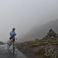
The morning of Saturday 6th June 2019 was wet. The ride began 7 minutes late at 04:07. The lights were essential and a white rain top was protecting my excellent Masonic Charitable Foundation cycling jersey, (size XXL!). The day grew lighter and the rain was replaced by ground mist, which seemed to recede as I approached it. The rain top was removed, rolled up and pushed into the middle back pocket of the jersey, where it stayed, as the weather did nothing but improve by the minute.
The first real test is Hardknott Pass. It is beautiful and very hard. It doesn’t begin gently either. There is a cattle grid at the start, which leads immediately into a 20 per cent plus hump. Taking care not to blow up, one simply has to keep turning the pedals, standing up for the very steep and adverse cambered hairpin bends. The legs and lungs cried enough three times and rests had to be taken before setting off again. Those cyclists who ride it all in one go are well out of my league. At one left hand bend under a drop off, I nearly jumped out of my skin as, from above there came a clanging of a cow bell and a loud voice shouting “Go on RICHARD!” It was about 05:00 and here was my young pal, who lives in Ambleside, bright and cheerful on his bike and with his camera. He’d got up at little come Devil time to cycle up the other side of this mountain just to cheer me on. It was a very welcome meeting.
He rode down the other side just behind me, shouting instructions as to the safest route down the wobbly, rumbly, slippery road. I have seen walls in the Peak District that were less steep than this descent.
The next test was Wrynose Pass. Not as steep as Hardknott. In a cycling book of the top 100 climbs in Britain, it is described thus “If Hardknott is the King of Climbs then Wrynose is surely its Queen!”. The approach is gentle. The legs are given chance to loosen up and get ready. Then it simply zig- zags its way up the mountain. It is very steep but, this time, I was able to ride it all non-stop although the photographs show that there was considerable puffing and blowing to reach the summit. The descent from Wrynose is downright dangerous. It wouldn’t get planning permission today. The ride down here was made with extreme care. The nagging reminder that a woman had died descending here only the weekend before, just would go out of one’s thoughts.
My pal led me all the way to Windermere, which saved ages that would be lost by stopping and map checking at all the junctions. This resulted in me being ahead of my imagined schedule. After a swift snack and saying goodbye I was back on my own and heading south to Bowness and the left turn pointing East towards Kendal.
Apart from the very steep climb immediately after turning East, just when I thought I’d finished with such torture, the ride to Kendal was easy and fast. Then I wasted time by getting lost for a few minutes looking for the road to Sedburgh. The route took me on yet another very steep climb under a railway bridge and up to the sky by a place called Park Head. That word “Head” makes a good warning to those relying on legs alone for their motive power! After rejoining the main road to Seburgh the going was once again easy and fast. The legs felt great and ready to ride to China and back. Crossing the M6 put me onto some very quick downhill riding, which is always a pleasure. The speed feels well-earned after such hills.
Then came a long undulating stretch up to Garsdale Head (“Head” again) and the border crossing into the County of my birth and infant nurture, Yorkshire. The road leads towards Hawes but the route forked left, North East onto Hardraw, Askrigg, Caperby, Redmire, Catterick Camp and crossing the A1 at Catterick. The climb up to Catterick Camp is tough. It climbs through a fault in a cliff face. As you pop over the summit you are greeted with a sign telling you that tanks turn here!
My “support team” were using an app to track me via the cellphone. They rose between 09:00 and 10:00 hours. They took a civilised breakfast and were finally ready to set off and catch me up and resupply me with food and water. My understanding is that once in the car and after switching on the tracking app they looked for me on the map. “Where is he?” “He’s not there!” “He must be!” Eventually, it dawned on them to zoom back and look further East. “He’s there!” “He can’t be, that’s miles away.” Two hours later they arrived where I had been only to find I had already gone. They did catch up with me at about 14:30 or thereabouts. Just in time as both of the one litre bottles were now empty, in despite of being refilled for me in Askrigg at a friendly café on the main road. My bottles full again, my pockets crammed with energy and protein bars I bid them good bye and set off again.
From Catterick the route takes minor roads over Killdale Moor then Danby Low Moor and North on a lovely unfenced, unwalled road up to the A171 main road into Whitby. Don’t ask me how they did it, but the support team found a pub to distract them and they missed me (and I missed them) just as I was heading North towards the A171.
Support team found me sat by the pier but they had been beaten to it by Malcolm and Linda Wilkinson who had come up from Chesterfield to cheer me in! To complete the trip properly it was essential to have some Fish n’ Chips in Whitby, which was duly carried out with gusto at the West Pier. A bit more climbing from Whitby to Sleights and an early night ready for a protein rich breakfast and a leisurely start for the return leg.
Sunday 7th July 2019 and the hardest bit of the ride was climbing out of Sleights up the Blue Bank and then slowly climbing the hills of the North York Moors and flying down their other sides. The route was fairly direct going via Fylingdales, Thornton-le-Dale, through the beautiful Vale of Pickering, Malton, Norton-on-Derwent, Buttercrambe, picking up the A166 to York. The traffic on the A166 was not a pleasant experience. The road surface is poor and folk forget that what they are buzzing by at 70 mph is actually a person on a bike and not a cone. Matters were made worse when the big roundabout over the A64 was reached. Google Earth shows traffic lights for pedestrians and cyclists to use to stop the traffic for a safe crossing. Real life shows that they have all been removed! It was necessary to take the chance and ride round the roundabout with all the 70 mph traffic. It was a relief to be away from that roundabout and heading through the University area down to Fulford, a very pretty place with lovely 18th century houses lining the road.
A right turn off the main road and away from the traffic and the route carries on through Stillingfleet, Cawood (pronounced Cay Wood, I checked with a local), Sherburn-in-Elmet, Monk Fryston, Hillam, Beale (a fascinating swing bridge here over the river Aire), Kellingly, Cridling Stubbs, then Darrington. Check this on the map and you will see this route was worked out to avoid the A1 and its slip road traffic and to avoid getting lost in Pontefract! The plan was a good one but it had a flaw. The level crossing between Cridling Stubbs and Darrington was closed. After some twenty minutes of polite requests and persuasion, the boss of the work being carried out by Network Rail came to see what was holding up his foreman. Maybe he liked my shirt. He gave instructions and I was chaperoned across to continue on to Darrington.
Heading almost due South, passing through some once attractive villages, like Brampton, Wentworth, Thorpe Hesley, under the M1 and into Sheffield and onto familiar roads. Maps no longer needed it was a case of pressing on to try and beat night fall into Bakewell. 270 miles in two days is not bad for a still overweight septuagenarian with hypertension now is it?
Congratulations Richard, a top effort!